Executive Summary
One Digital Fabric.
Instant Answers.
The AI-DGGS Pilot successfully demonstrated a breakthrough in disaster response: giving Artificial Intelligence a Geospatial Brain. By unifying global data standards, we proved that AI can now interpret a crisis as easily as it interprets text.
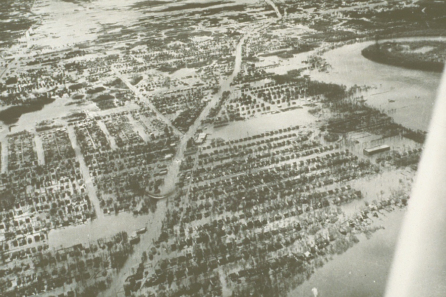
The Challenge: Fragmented Ground Truth
In a crisis, decision-makers are buried in data but starved for information. Satellite imagery, flood models, and infrastructure maps speak different languages. This pilot addressed the "Discovery Gap"—the barrier that prevents responders from getting instant answers to plain-language questions.
The Innovation: A Universal Language
We created a Digital Fabric with Discrete Global Grid Systems (DGGS)—a global grid that aligns every piece of data perfectly. ") Then, we orchestrated AI how to read it. We enabled 4 independent AI clients and 6 DGGS data servers to work as a single, interoperable engine.
Then, we orchestrated AI how to read it. We enabled 4 independent AI clients and 6 DGGS data servers to work as a single, interoperable engine.
The Future: Actionable Intelligence
Decision-makers can now use plain-language queries to answer questions about disasters, like identifying high-risk zones for flooding. The pilot successfully unified geospatial data for the Red River Basin Canada, demonstrating how DGGS and AI can enable more resilient emergency response.
Explore Technical FindingsThe Challenges
Closing the "Discovery Gap" in a Crisis
From Searching for Data to Finding Answers.
In a disaster, decision-makers are buried under a "discovery gap"—where the volume of available satellite and weather data exceeds the human ability to find, query, and map it in real-time.
The pilot was designed to test if Discrete Global Grid Systems (DGGS) could serve as the "unifying fabric," allowing Generative AI to act as a bridge so a non-specialist can simply ask a question and receive a spatially accurate response.
The Chat-to-Map Vision
"Identify the neighborhoods south of Winnipeg where high snowmelt signals overlap with critical power infrastructure."
The "Where" Problem
AI agents speak in locations (e.g., "Manitoba"), but maps speak in complex DGGS Zone IDs. The challenge was teaching AI to automatically translate human geography into the millions of grid cells required for a precise answer.
Geometric Trust
During a flood, being "close enough" isn't enough. The pilot had to address the friction of aligning disparate grids onto a single ellipsoidal model to ensure that an AI-generated risk zone aligns perfectly with the physical terrain.
The "Overload" Effect
AI can be "too curious," requesting far more data than a server can provide. We had to investigate Architectural Guardrails that force the AI to query the big picture first, then drill down into high-resolution grid details only where risk is highest.
Real-Time Response
Traditional formats are too heavy for mobile responders. The pilot explored how Spatial Tokenization via DGGS can compress complex risk summaries, ensuring they reach a field officer’s device in seconds, not minutes.
The Pilot Scenario
Red River
Basin Operations
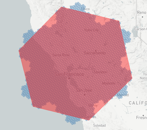
Focusing on the high-consequence flood corridor in Manitoba, Canada—from Winnipeg south to the US border.
Modeled after the historic floods of 2011 and 2022, the pilot demonstrates how OGC standards can unify fragmented data for real-time Emergency Response.
Mission Goal
To deliver an Intelligent Common Operating Picture (COP). We move beyond simple maps to "Explainable AI," where every risk prediction is linked to authoritative DGGS grid cells.
Integrated Data Portfolios
RCM ARD (Radar)
Weather & Hydrology
Terrain (CDEM/LiDAR)
Socio-Population
Critical Infrastructure
NAPL Archives
Architecture
A Hybrid Interoperability Framework designed to ground Generative AI in authoritative geospatial grids.
By decoupling heavy data processing (D100 Servers) from intelligent reasoning (D102 Clients), the pilot enables real-time decision support through standardized Technology Integration Experiments (TIEs).
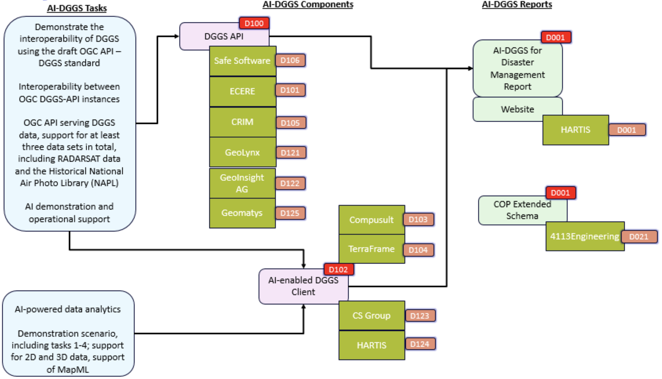
The Server Backbone
Federated Grid Servers
Moves the "heavy lifting" close to the source. Six independent implementations quantize satellite and terrain data into the DGGS fabric to ensure system scalability during massive data requests.
- Pre-Quantization: Servers calculate complex Hydrological Indexes before the user even asks a question.
- Cloud-Native Pointers: Transmits "intelligence tokens" (COG/Zarr refs) rather than heavy pixels to save bandwidth.
- TIE Validation: Standardized OGC APIs allow data from one vendor to be fused with analysis from another.
The Intelligence Frontier
Agentic AI Analysts
Transforms map viewers into proactive tools capable of performing "Lightweight Fusion" and real-time natural language interaction.
Anchors reasoning in physical DGGS cells to prevent hallucinations and ensure responses are grounded in "Ground Truth."
Allows agents to autonomously "read" server capabilities and chain API calls across different vendors to solve the user's query.
DGGS Frictions
Closing the gaps between the OGC DGGS API Standard and real-world software implementations.
The pilot identified technical bottlenecks where theoretical specifications encountered the practical constraints of bandwidth, mathematical precision, and AI reasoning. By documenting these six frictions and their standards-based fixes, we establish a path toward Geospatial Grounding—ensuring that autonomous agents receive mathematically identical and scientifically traceable results across a federated network of disparate vendors.
Geometric Alignment
Widely used grid systems like H3 were built on authalic spherical models, but the proper mapping to reference ellipsoidal geodetic systems, such as WGS84, is ambiguous. In a flood scenario, these deviations can lead to risk data being mapped to the wrong physical location.
THE INTEGRATION FIX
The pilot clarified that WGS84 geodetic latitude should be mapped to authalic latitude for H3, and zone boundaries should be refined with intermediate points on the authalic sphere. This maintains topological relationships across levels, ensuring risk zones are mathematically accurate on the Earth's physical surface.
The "Data Hole" Problem
Satellite data is often "sparse," containing large gaps for areas the sensor did not pass over. Standard web formats often treat these empty spaces as uncompressed pixels or values, leading to bloated file sizes that can slow down map response times during an active crisis.
THE PERFORMANCE FIX
The pilot utilized optimized data encodings like DGGS-UBJSON(-FG) and Parquet combined with high-ratio compression to collapse empty space. This ensures data storage is significantly smaller and faster to transmit to field officers.
The Stacking Paradox
In Aperture 7 grids like H3, a parent hexagon does not perfectly contain its children. At every level of depth, some "logical" children extend outside the parent boundary, while "neighboring" children bleed into it.
THE ACCURACY FIX
Ignoring these overlaps results in replacing ~6.52% of the analysis area with data from the wrong location. The pilot implemented topological tools to account for the actual 13 overlapping sub-zones rather than just the logical 7.
Coarse Depth: 7-Child Drift
Fine Depth: Persistent Fractal Issue
Visual Proof: These images show that H3 hexagons are not "nested." The visible blue parts or small child cells show the ~6.52% of space where the parent and children cells do not match. This property remains across zone depths.
Cross-Platform Integrity
To be effective, disaster tools must work everywhere—from heavy cloud servers to a responder's field tablet. Previously, grid mathematics was often incompatible across different programming languages or environments.
THE INTEROPERABILITY FIX
The pilot successfully validated the DGGAL library across Python, Java, Rust, and WebAssembly (WASM). This ensures consistent, high-speed grid results across federated geospatial ecosystems.
The 4D Resolution Wall
Disaster modeling requires high-resolution data in both space and time (sub-meter / sub-hour). Moving from daily to minute-level time-steps creates a "temporal explosion" that makes 4D range queries (XYZT) computationally heavy, often leading to system timeouts.
THE SCALABILITY FIX
The pilot demonstrated using DGGS cells as Intelligent Pointers. Coarse cells provide 4D summary stats (e.g., max crest height over a 24h window) while providing direct links to Zarr or GeoParquet cubes for the full-resolution payload.
The Interpretation Gap
AI agents can retrieve raw values but suffer from "Contextual Blindness." Without explicit metadata, an agent cannot distinguish if a number is a flood depth in meters or a probability percentage, leading to "geospatial hallucinations."
THE PROVENANCE FIX
The pilot prototyped Self-Describing Grids by embedding STAC extensions and IPT metadata. This provides the context for AI to autonomously verify unit semantics and aggregation methods (Sum vs. Mean), making insights scientifically traceable.
AI Orchestration
Enabling the "Agentic" Frontier
From Passive Chatbots to Autonomous Analysts.
Integrating AI into the DGGS ecosystem revealed that general-purpose LLMs suffer from 'Scale Blindness'—a lack of native logic to realize that a simple request for sub-meter modeling across a province translates into a trillion-point computational burden.
The pilot proved that safe disaster response requires an Orchestration Layer: a spatial intermediary that reconciles human intent with the physical limits of server infrastructure through iterative, standards-based reasoning.
The Orchestration Goal
If an AI agent is to be trusted in a crisis, it must be cured of its "Scale Blindness." The goal of our Orchestration Layer is to act as the AI’s Spatial Conscience, translating human intent into high-resolution reality. We are evolving the LLM from a passive narrator into a Geospatial Analyst that understands the mechanics of disaster—ensuring every request is grounded in scientific modeling and geospatial standards.
Descriptive Grounding
General AI summarizes text; Descriptive AI reports grid-truth. Orchestration ensures the AI "reads" the DGGS cell values directly, preventing hallucinations by anchoring the narrative in actual sensor data.
Machine-Ready APIs
Through the Model Context Protocol (MCP), OGC APIs provide standardized capability disclosure. AI agents can autonomously discover endpoints, allowing them to plan complex workflows without human assistance.
The "Semantic Gap"
A major pilot discovery: AI agents require Semantically-Aware Data. Without explicit descriptors for units and quantization logic, agents cannot independently determine if a dataset is fit-for-purpose.
Algorithmic Provenance
AI agents must understand Inductive Bias. The pilot demonstrated the need to document regridding methods (like K-NN) used during quantization so that models can interpret mathematical artifacts correctly.
STAC Meta-Extensions
Moving beyond simple schemas, the pilot advocated for embedding STAC Extensions (Disaster, ML Models, and Processing) directly into the DGGS metadata to ensure data is "Self-Describing" for AI.
Semantic Reasoning
General AI knows words; Spatial Knowledge Graphs (SKGs) know relationships. By linking the grid with formal ontologies, the AI understands Cascading Risks—such as a flooded substation in one cell knocking out power to a hospital in another.
Geospatial Foundation Models (GeoFMs)
The pilot identified the need for Small, Domain-specific models. These shall not only be trained on OGC standards and grid math, but must be embedded with Scientific Knowledge—understanding the physics of floods to provide reliable, edge-side emergency reasoning.
The Server Ecosystem
DGGS Server Infrastructure
Six independent implementations providing the backbone for the "Any Data, Any Grid" pilot philosophy.
DGGS Server Implementation (D105)
CRIM: The Data Integrators
Automated Pipelines for Radar and Population Data Ingestion.
CRIM led the development of high-volume data pipelines, converting raw scientific observations into a unified grid fabric. Their work focused on ensuring that AI agents could query spatially consistent environmental and demographic signals.
- pydggsapi & Birdhouse: Leveraged a Python-based FastAPI implementation integrated with the Birdhouse ecosystem to handle high-volume geospatial processing.
- RCM Analysis-Ready Data (ARD): Developed automated workflows to ingest RADARSAT Constellation Mission (RCM) ARD, enabling dynamic flood extent mapping via DGGS-JSON.
- Socio-Demographic Integration: Integrated Canada Population Statistics to explore interoperability and index conversions between H3 and IGEO7 representations.
- STAC-Native Ingestion: Built optimized connectors to harvest data directly from SpatioTemporal Asset Catalogs, streamlining the flow from satellite archives to the DGGS grid.
DGGS Server Implementation (D101)
Ecere: The Standards Architects
Providing the Foundational Library for High Performance Interoperable Spatial Tokenization Across Grid Hierarchies.
With a co-editor role, Ecere led the development of the OGC API - DGGS Standard and provided the open-source Discrete Global Grid Abstraction Library (DGGAL), implementing the pilot's mathematical foundation.
- Multi-Grid Support: Added support for multiple grid hierarchies to DGGAL: aperture 7 hexagonal (7H), aperture 4 rhombic (4R), and HEALPix, complementing existing support for multiple equal-area projections.
- Multi-Language/Platform Support: Provided bindings for DGGAL (written in eC) for C, C++, Rust, Python, and JavaScript (WASM), and collaborated with Geomatys for Java.
- Scanline-Based Iteration: Designed a scanline-based deterministic order for 7H sub-zones and implemented a corresponding efficient iteration algorithm.
- Area Under the Fractal Curve: Discovered a combinatorial solution to quantify the exact misassignment (~6.52%) performing aggregation using logical (indexing) 7H descendant zones.
- Scalable DGGS Data Stores: Demonstrated the practicality of scalable stores for quantized data using SQLite/DGGS-UBJSON(-FG) blobs with "High Vibes" tools.
- H3 for DGGS API: Clarified topological relationships and established a clear mapping to coordinates referenced to the WGS84 ellipsoid.
DGGS Server Implementation (D122)
GeoInsight: Performance Engineers
Edge-Aware Execution and Efficient Raster Quantization.
GeoInsight addressed the scalability bottleneck of serving massive datasets during a crisis by combining edge-aware execution, efficient raster quantization, and tokenized spatial representations suitable for analytical and AI-driven workflows.
- Spatial Tokenization & Quantization: Developed a reusable algorithm that converts COGs into DGGS-addressed representations, transforming continuous geospatial fields into discrete Spatial Tokens aligned with grid cells.
- High-Performance Rust: Utilized a high-concurrency Rust architecture to move heavy analytical processing closer to the data source, ensuring near-instant response times.
- DuckDB & Parquet: Leveraged columnar storage and embedded analytical engines to handle millions of H3 grid cells without the performance penalties of traditional row-based databases.
- Cloud-Native Flexibility: Validated an architecture where DGGS tiles act as spatial indices pointing to external COG or Zarr files, supporting the "Any Data, Any Grid" pilot philosophy.
DGGS Server Implementation (D121)
Geolynx: Open-Source Innovators
Empowering the Python Ecosystem through Accessible Grid Mathematics.
The University of Tartu team provided the foundational tooling for the pilot, bridging the gap between academic research and operational software. By making complex grid math accessible via standard Python libraries, they enabled rapid prototyping across the entire D100 ecosystem.
- pydggsapi & dggrid4py: Developed the core FastAPI implementation and Python wrappers that powered multiple pilot servers, ensuring a consistent interface for DGGS data discovery.
- Inter-DGGRS Conversion: Successfully demonstrated experimental on-the-fly conversion between IGEO7 and H3, proving that data storage can be decoupled from client delivery requirements.
- Scientific Data Stack: Engineered support for Zarr and Parquet backends, allowing the research community to utilize high-performance columnar formats within a DGGS structure.
- Xarray Integration: Contributed to the alignment of DGGS with the Pangeo ecosystem, enabling AI agents to process multi-dimensional arrays without manual coordinate handling.
DGGS Server Implementation (D125)
Geomatys: Multi-Dimensional Experts
Solving the Complexity of 5D Data and Intelligent Discovery.
Using the Examind Server (built on Apache SIS), Geomatys tackled the challenge of integrating high-velocity data across Space, Time, and Height, making dense data cubes navigable for autonomous AI agents.
- The Discovery Endpoint: Proposed and implemented the
/zonesdiscovery capability, allowing AI agents to query grids via natural geography (BBOX) and retrieve associated summary values. - OGC GeoAPI DGGRS Preview: Leveraged previous DGGRS testbeds and libraries (H3geo, S2geometry, CDS-Healpix, DGGAL) to create functional, interoperable DGGRS implementations.
- Multidimensional Scaling: Engineered solutions for 5D data challenges, enabling AI to perform temporal aggregations and vertical risk analysis within DGGS-JSON and -FG structures.
- Performance Benchmarking: Conducted rigorous testing of Healpix and H3 implementations, providing critical data on response times for global-scale datasets.
DGGS Server Implementation (D106)
Safe Software: Workflow Orchestrators
Orchestrating "Any Data, Any Grid" through No-Code Automation.
Safe Software successfully demonstrated how its enterprise Extract, Transform, Load (ETL) platform, FME, bridges the critical gap between traditional geospatial systems and grid-native Artificial Intelligence. By utilizing the Feature Manipulation Engine, Safe Software validated that diverse, high-volume datasets, such as Manitoba DEMs, NetCDF climate projections, and historical flood models, can be served as OGC-compliant DGGS endpoints without any custom coding.
These innovations supported Hartis' Flood Impact Index and TerraFrame's Spatial Knowledge Graphs to identify risks and infrastructure failures. Ultimately, the pilot proved that model-based, no-code automation provides the auditable interoperability required for agentic AI.
- Data Virtualization: FME workflows were loaded into shareable open APIs, enabling on-the-fly transformation of legacy data streams into DGGS fabrics without manual preprocessing.
- FME Hub Transformers: New tools like DGGSEncoder and DGGSJSONDecoder were developed to wrap Ecere's DGGAL libraries, allowing the quantization of vector and raster data into machine-readable spatial tokens.
- Multi-Format Connectivity: Diverse integrations bridged traditional GIS formats with AI-ready grids, ensuring data accessibility for non-experts.
- Real-Time Capabilities: A dynamic 'realtime-flood-sim' layer for the Red River showcased how AI agents can interact with live and time-series feeds during crises and support scenario analysis.
Agentic AI Clients
AI-Enabled Decision Support
Transforming raw grid data into natural language insights through RAG and Model Context Protocols.
AI Client Implementation (D123)
CS Group: Autonomous Agent Architects
Orchestrating Complex Workflows via the Model Context Protocol (MCP).
CS Group pushed the boundaries of the pilot by evolving the AI from a text generator into a planning agent. By championing a system where the AI autonomously "reads" server metadata, they enabled the automation of complex geospatial workflows without human intervention.
- Agentic AI Workflows: Developed a sophisticated reasoning engine that plans multi-step tasks—such as finding a flood zone, querying local population density, and reporting cumulative impact—in a single execution.
- MCP Strategic Adoption: Championed the Model Context Protocol (MCP) to standardize how AI agents discover, interpret, and interface with DGGS API capabilities, eliminating the need for vendor-specific hard-coding.
- Standardized Discovery: Validated the use of DGGAL (WASM) within a React-based environment, allowing the client to handle high-speed grid logic and coordinate resolution directly in the browser.
- Multi-Vendor Orchestration: Successfully demonstrated interoperability by chaining API calls across independent server implementations (Ecere, Geomatys, Safe), creating a truly federated decision-support ecosystem.
AI Client Implementation (D103)
Compusult: User Experience Pioneers
Bridging the Gap Between Natural Language and Interactive Mapping.
Compusult focused on the human-centered reality of the pilot, developing the primary **React-based chatbot client**. Their work demonstrated that non-experts could query petabytes of geospatial data using plain English and receive instant, visualized results.
- Chat-to-Map Integration: Engineered the first functional "Chat-to-Map" interface, where a user types a query like "Show me the flood risk for Winnipeg," and the system automatically renders precise DGGS zones on a Leaflet map.
- Dynamic Data Parsing: Developed agentic capabilities to interpret complex OGC API Feature structures, automatically guiding the user through file hierarchies (KML, SHP, WMS) to find the most relevant layers.
- DGGAL WebAssembly (WASM): Successfully integrated the DGGAL library via WASM to perform high-speed grid logic directly in the browser, ensuring a responsive user experience during rapid query cycles.
- Semantic Search Strategy: Leveraged Retrieval-Augmented Generation (RAG) to help AI agents autonomously identify locations within queries and zoom the map to the specific Red River corridor Areas of Interest (AOI).
AI Client Implementation (D124)
Hartis: Decision Intelligence
Grounding Generative AI in the Flood Impact Index (FII).
Hartis led the development of the Flood Impact Index (FII), a sophisticated model designed to transform raw grid data into explainable emergency intelligence. By utilizing the H3 Level 8 fabric, they enabled AI agents to provide forward-looking, spatially consistent risk indicators.
- Multi-Source Fusion: Developed a composite indicator that fuses satellite flood extents (RCM ARD), weather predictions (GEPS), and high-resolution terrain data into a single risk score per grid cell.
- Spatially Grounded AI: Implemented a Retrieval-Augmented Generation (RAG) workflow that prevents AI hallucinations by forcing the LLM to base its reasoning on authoritative DGGS cell data.
- Hydrological Precision: Integrated HAND (Height Above Nearest Drainage) and flow accumulation indices to identify flood susceptibility South of Winnipeg with unprecedented accuracy.
- Explainable Risk: Enabled "Chat-to-Map" functionality where AI agents explain why specific zones are at risk, such as identifying the overlap of snowmelt signals with critical infrastructure.
AI Client Implementation (D104)
TerraFrame: Semantic Integrators
Transforming Natural Language into Precise Spatial Evidence.
TerraFrame bridged the gap between raw grid data and operational intelligence by enabling AI agents to perform Semantic Spatial Reasoning. Their implementation allows users to query complex disaster parameters without specialized GIS training.
- Threshold-Based Querying: Demonstrated the ability for AI to parse natural language constraints—such as "water level > 11"—and translate them into filtered DGGS cell requests.
- Infrastructure Interconnectivity: Integrated Spatial Knowledge Graphs (SKG) to identify specific impacted assets like the Pembina Highway and Provincial Road 200 based on flood-cell intersections.
- Traceable Decision Support: Utilized GeoSPARQL and linked data to ensure every AI-identified "impacted road" is backed by authoritative server-side collection data and specific spatial codes.
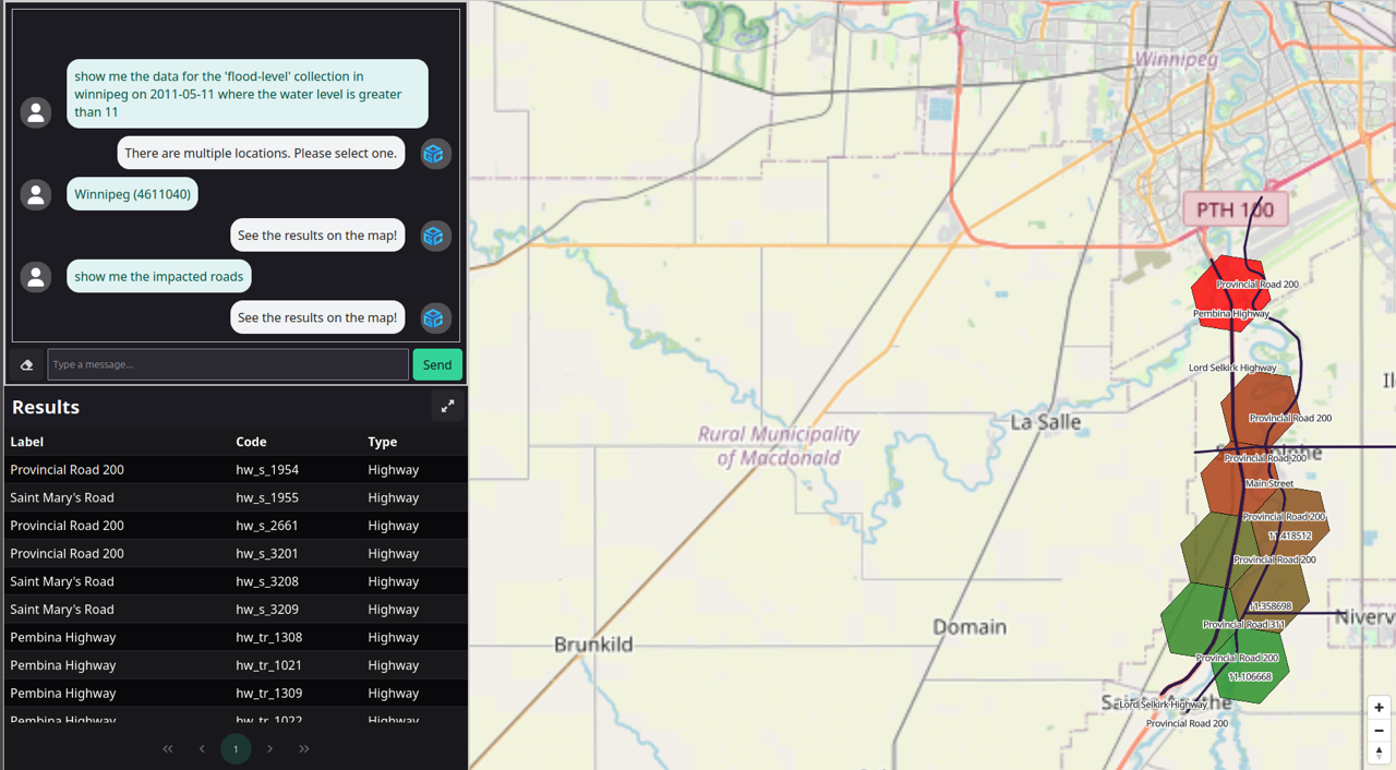
Semantic Reasoning: Chat-to-Map Infrastructure Impact
Technical Evidence: This visual captures an AI agent resolving a multi-step query. It first identifies flood levels above a specific threshold (>11) in Winnipeg, then cross-references those cells with infrastructure data to generate an actionable table of impacted transport links, including Provincial Road 200 and Saint Mary's Road.
Standardization
Evolving OGC specifications from data retrieval protocols into Geospatial Reasoning Frameworks.
To transition from "Chatbots" to "Geospatial Analysts" OGC standards must move toward Autonomous AI Services & Data Discovery, allowing machine-to-machine interaction at a global scale.
Strategic Goal
To eliminate the "Implementation Gap" between disparate vendors, ensuring that an AI agent requesting "Risk Tokens" receives an identical mathematical response from any server in the federated network.
- Geospatial Grounding
- Multi-Grid Interoperability
- Provenance-Backed Mapping
-
1
-
2a
-
2b
-
3
-
4
-
5
-
6
Operational Alignment Matrix
Mapping roadmap steps to the DGGS frictions they resolve and the AI frontier enablers they activate.
| Step | Standardization Action | Solves DGGS Friction | Activates AI Frontier Enabler |
|---|---|---|---|
1 |
Authoritative DGGRS Register |
4. Cross-Platform Integrity
|
2. Machine-Ready APIs
|
2a |
Spatial Discovery API Extensions |
5. 4D Resolution Wall
|
1. Descriptive Grounding
|
2b |
Semantic Metadata |
6. Interpretation Gap
|
5. STAC Extensions
3. Semantic Gap Fix
|
3 |
Formal Best Practice for H3 |
1. Geometric Alignment
|
7. Scientific Foundation
|
4 |
Temporal "Regridding" Parameters |
5. 4D Resolution Wall
|
2. Machine-Ready APIs
|
5 |
Auditable Common Operating Picture |
6. Interpretation Gap
|
6. Semantic Reasoning
4. Algorithmic Provenance
|
6 |
Advanced Analytical Extensions |
3. Stacking Paradox
|
1. Descriptive Grounding
|
Partners
A Global Consortium for Geospatial Resilience.
The AI-DGGS Pilot is a collaborative research bringing together national agencies, research institutes, and technology leaders to define the future of disaster management.
Pilot Sponsors
These organizations provide the strategic vision, authoritative data, and oversight necessary to advance OGC and ISO standards for real-world crisis response.
Voices from the Field
Operational Perspective
Critical observations on the pilot's utility for active Emergency Management Divisions.
Focus Area:
Disaster Response & Deployment Timelines
"The introduction of AI provided an easier interface for operators like me to use technical tools to ask relevant emergency management questions... I can see opportunities in the future as more work is invested in streamlining and normalizing the technology."
The pilot enabled a better understanding of how to deploy and utilize this technology in future operations.
Direct discussion on barriers provided a realistic understanding of implementation timelines.
Mai Gagujas
DGGS Server Participants
DGGS Server Participants engineered the high-performance grid backbone, deploying federated servers that transform massive planetary datasets into standardized, AI-ready DGGS cells.
AI Client Participants
AI Client Participants pushed the frontier of Agentic AI, developing intelligent clients that utilize Retrieval-Augmented Generation (RAG) and the Model Context Protocol (MCP) to translate natural language into spatial insights.
Technical Documentation
Final Engineering Report
This report provides the formal record of the 2025 AI-DGGS Pilot. It details the architectural consensus reached to bridge the gap between autonomous AI reasoning and the rigid requirements of high-resolution geospatial grids.
Core Technical Outcomes
- Multi-Vendor Interoperability: Demonstrated successful interoperability between several OGC API - DGGS Clients (4) and Servers (6), for several different DGGRSs, validating the Standard in an operational environment.
- DGGAL Validation: Testing the DGGAL library across multiple runtimes (Python, Java, Rust, WASM), proving the portability of OGC grid math across diverse software ecosystems.
- Agentic AI Orchestration: Evaluation of the Model Context Protocol (MCP) in enabling AI agents to autonomously discover and interface with federated DGGS endpoints.
- Scalable Infrastructure: Performance findings on the use of compressed DGGS-UBJSON(-FG) blobs and Parquet to manage high-velocity data "holes" without bandwidth penalties.
- Analytical Quantification: Proposals for Quantization Extensions to standardize how data is aggregated (min/max/average) per grid cell, ensuring scientific "Ground Truth" for disaster modeling.